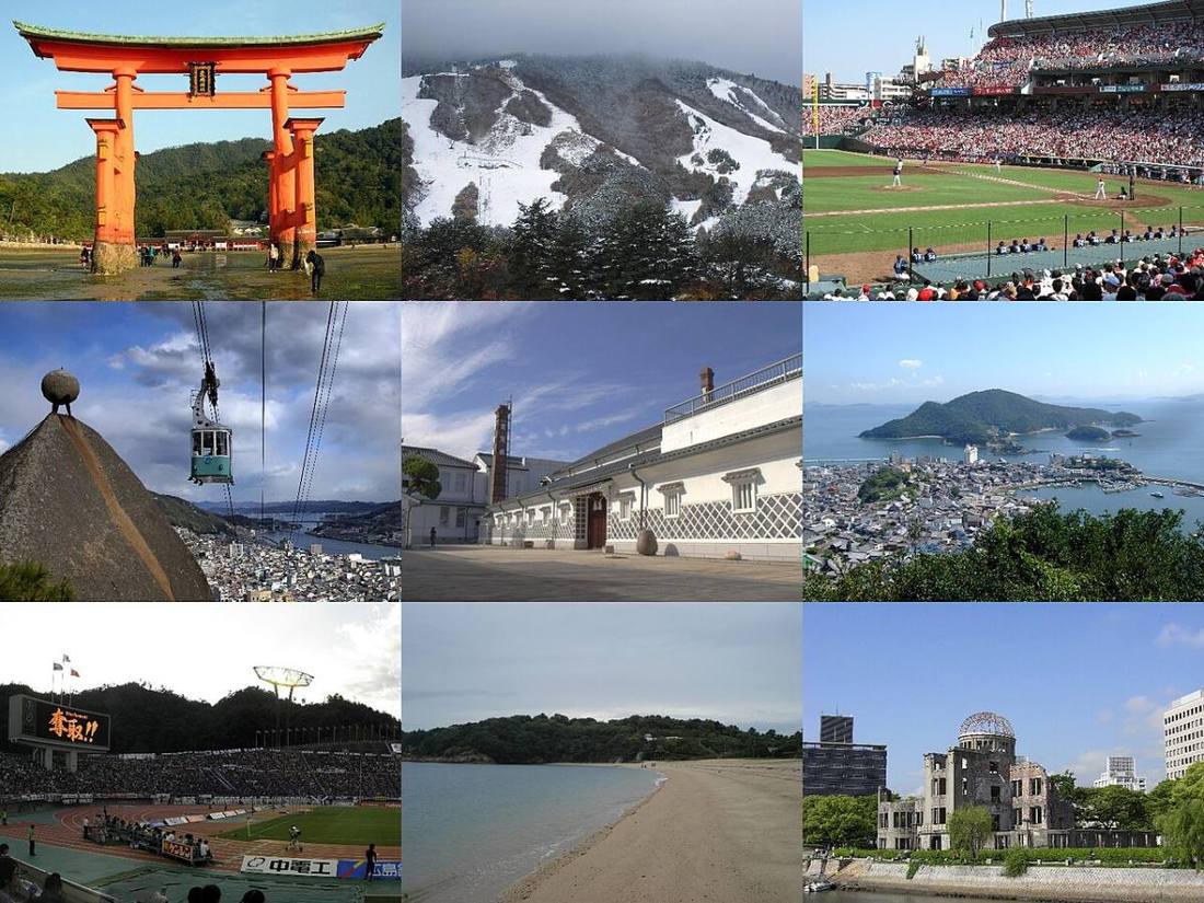
Photo: File:Torii and Itsukushima Shrine.jpg by User:Bernard Gagnon
File:Hiroshima Peace Memorial 2008 02.JPG by User:Taisyo
Fi / CC BY 3.0 · Wikimedia Commons
Hiroshima Prefecture
Chugoku region · Prefecture
Official website
Hiroshima Prefecture is the largest prefecture in the Chugoku and Shikoku regions. It has 2 World Heritage Sites, the Atomic Bomb Dome and Itsukushima Shrine, and it continues to send its prayers for peace out to the world. Its oyster farming ranks 1st in Japan, and okonomiyaki (savory pancakes) and lemons are also local specialties.
- Atomic Bomb Dome and Itsukushima Shrine (World Cultural Heritage Sites)
- Oysters
- Hiroshima-style okonomiyaki
- Shimanami Kaido
Key facts
- Municipalities
- 23 (14 cities, 9 towns)
Source: Statistics Bureau of Japan, 2025 Population Census (population, area and density); area from the Geospatial Information Authority of Japan (GSI), Area Statistics of Prefectures and Municipalities (2025). National ranks are among the 47 prefectures, ordered by this site from these values.
Places to know
- Hiroshima City Hiroshima Peace Memorial Park. The only city in the Chugoku and Shikoku regions with a population of 1 million.
- Hatsukaichi City Miyajima, with its great torii gate that seems to float on the sea.
- Onomichi City A town of slopes and literature, and the starting point of the Shimanami Kaido (a route of bridges across the islands of the Seto Inland Sea).
Current warnings, advisories and earthquakes
Places to visit in Hiroshima Prefecture
Browse by category
Shrines, temples, castles and historic sites
Chosen automatically, most popular first, from landmarks and cultural properties registered in Wikidata (we have not checked whether each is open). Names and descriptions: Wikidata (CC0); photos: Wikimedia Commons (photographer and license under each photo).
National parks in Hiroshima Prefecture
- Setonaikai National ParkTotal park area 673 km²Also in Hyogo, Wakayama, Okayama, Yamaguchi, Tokushima, Kagawa, Ehime, Oita
Chosen by overlaying the park boundaries (Ministry of the Environment, Biodiversity Center of Japan, "National Park Areas" GIS data, updated April 28, 2025, combined and simplified by NIPPON ATLAS) with municipal boundaries (National Land Numerical Information, January 2021), keeping overlaps of about 0.5 km² or more (approximate). Areas are the land areas from the Ministry of the Environment, "Overview of National Parks" (April 10, 2026). All national parks
Municipalities in Hiroshima Prefecture (23)
| Municipality | Population | 5-year change | Area | Temperature nownearest AMeDAS |
|---|
| Hiroshima City | 1,171,915 | −2.4% | 907 km² | |
| Kure City | 191,584 | −10.7% | 352 km² | |
| Takehara City | 21,739 | −9.4% | 118 km² | |
| Mihara City | 83,881 | −7.4% | 472 km² | |
| Onomichi City | 120,215 | −8.4% | 285 km² | |
| Fukuyama City | 440,422 | −4.4% | 518 km² | |
| Fuchu City | 33,367 | −11.4% | 196 km² | |
| Miyoshi City | 46,559 | −8.1% | 778 km² | |
| Shobara City | 29,598 | −12.0% | 1,246 km² | |
| Otake City | 24,648 | −6.3% | 78.66 km² | |
| Higashihiroshima City | 198,502 | +1.0% | 635 km² | |
| Hatsukaichi City | 111,833 | −2.0% | 489 km² | |
| Akitakata City | 24,694 | −6.6% | 538 km² | |
| Etajima City | 19,716 | −10.1% | 101 km² | |
| Fuchu Town | 51,172 | +0.0% | 10.41 km² | |
| Kaita Town | 30,063 | +1.4% | 13.79 km² | |
| Kumano Town | 22,440 | −1.7% | 33.76 km² | |
| Saka Town | 12,015 | −4.5% | 15.69 km² | |
| Akiota Town | 5,039 | −12.2% | 342 km² | |
| Kitahiroshima Town | 15,912 | −10.4% | 646 km² | |
| Osakikamijima Town | 6,484 | −9.4% | 43.11 km² | |
| Sera Town | 13,721 | −9.3% | 278 km² | |
| Jinsekikogen Town | 7,267 | −11.9% | 382 km² | |
Source: Statistics Bureau of Japan, 2025 Population Census (population in 2025; change compared with 2020). Area: GSI (2025). Designated cities are shown as one city (wards combined). "Temperature now" is the latest JMA AMeDAS observation (preliminary) at the nearest station in the same prefecture, loaded and shown unchanged when you open the page.