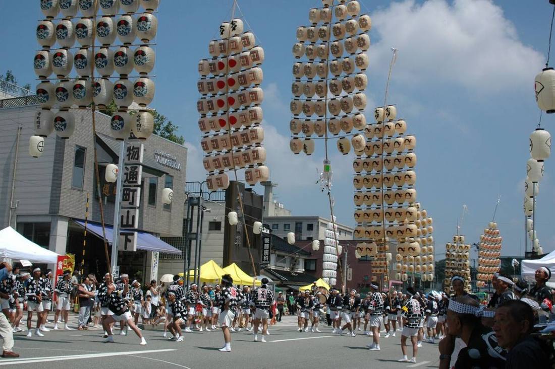
Photo: STB-1 / CC BY-SA 3.0 · Wikimedia Commons
Akita Prefecture
Hokkaido & Tohoku region · Prefecture
Official website
Akita is a major rice-growing prefecture, known for the Akitakomachi rice variety, and it has many well-known sake breweries. Culture born from life in snow country remains strong, such as the Namahage, the Kanto Festival and kiritanpo (grilled rice sticks).
- Akitakomachi rice
- Namahage
- Kanto Festival
- Akita dogs
Key facts
- Municipalities
- 25 (13 cities, 9 towns, 3 villages)
Source: Statistics Bureau of Japan, 2025 Population Census (population, area and density); area from the Geospatial Information Authority of Japan (GSI), Area Statistics of Prefectures and Municipalities (2025). National ranks are among the 47 prefectures, ordered by this site from these values.
Places to know
- Akita City The Kanto Festival, with lanterns swaying in the summer night sky.
- Oga City The home of the Namahage ritual on New Year's Eve.
- Semboku City The samurai houses of Kakunodate, Lake Tazawa and Nyuto Onsen.
Current warnings, advisories and earthquakes
Places to visit in Akita Prefecture
Browse by category
Shrines, temples, castles and historic sites
Chosen automatically, most popular first, from landmarks and cultural properties registered in Wikidata (we have not checked whether each is open). Names and descriptions: Wikidata (CC0); photos: Wikimedia Commons (photographer and license under each photo).
National parks in Akita Prefecture
Chosen by overlaying the park boundaries (Ministry of the Environment, Biodiversity Center of Japan, "National Park Areas" GIS data, updated April 28, 2025, combined and simplified by NIPPON ATLAS) with municipal boundaries (National Land Numerical Information, January 2021), keeping overlaps of about 0.5 km² or more (approximate). Areas are the land areas from the Ministry of the Environment, "Overview of National Parks" (April 10, 2026). All national parks
Municipalities in Akita Prefecture (25)
| Municipality | Population | 5-year change | Area | Temperature nownearest AMeDAS |
|---|
| Akita City | 293,351 | −4.7% | 906 km² | |
| Noshiro City | 45,437 | −9.1% | 427 km² | |
| Yokote City | 77,495 | −9.4% | 693 km² | |
| Odate City | 63,226 | −8.7% | 913 km² | |
| Oga City | 21,566 | −14.3% | 241 km² | |
| Yuzawa City | 37,420 | −11.1% | 791 km² | |
| Kazuno City | 25,622 | −11.9% | 708 km² | |
| Yurihonjo City | 69,154 | −7.4% | 1,210 km² | |
| Katagami City | 30,235 | −4.7% | 97.72 km² | |
| Daisen City | 71,040 | −8.5% | 867 km² | |
| Kitaakita City | 26,531 | −12.1% | 1,153 km² | |
| Nikaho City | 21,166 | −9.7% | 241 km² | |
| Semboku City | 21,644 | −12.1% | 1,094 km² | |
| Kosaka Town | 4,209 | −11.9% | 202 km² | |
| Kamikoani Village | 1,703 | −17.5% | 257 km² | |
| Fujisato Town | 2,526 | −12.8% | 282 km² | |
| Mitane Town | 13,124 | −14.0% | 248 km² | |
| Happo Town | 5,631 | −14.4% | 234 km² | |
| Gojome Town | 7,250 | −15.1% | 215 km² | |
| Hachirogata Town | 4,951 | −11.3% | 17.00 km² | |
| Ikawa Town | 4,006 | −12.3% | 47.95 km² | |
| Ogata Village | 2,824 | −6.2% | 170 km² | |
| Misato Town | 16,786 | −9.8% | 168 km² | |
| Ugo Town | 12,279 | −11.2% | 231 km² | |
| Higashinaruse Village | 2,294 | −15.2% | 204 km² | |
Source: Statistics Bureau of Japan, 2025 Population Census (population in 2025; change compared with 2020). Area: GSI (2025). Designated cities are shown as one city (wards combined). "Temperature now" is the latest JMA AMeDAS observation (preliminary) at the nearest station in the same prefecture, loaded and shown unchanged when you open the page.