Photo: Makoto_Lab / CC BY 4.0 · Wikimedia Commons
Miyagi Prefecture
Hokkaido & Tohoku region · Prefecture
Official website
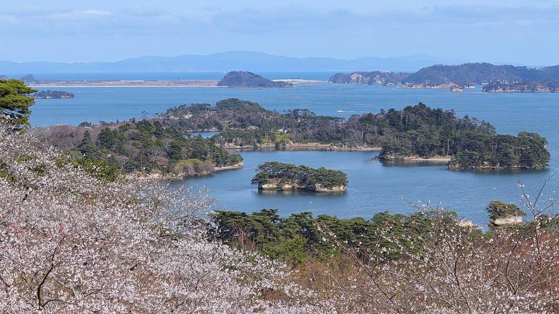
Miyagi is the center of the Tohoku region and is home to Sendai, the only designated city (a major city with powers similar to a prefecture) in Tohoku. It combines the attractions of a city with seafood and local food such as Matsushima, one of the Three Views of Japan, gyutan (grilled beef tongue), sasa-kamaboko (leaf-shaped fish cakes), and shark fin and oysters from Kesennuma.
- Mori no Miyako (City of Trees)
- Matsushima, one of the Three Views of Japan
- Gyutan (beef tongue)
- Date Masamune
Key facts
- Municipalities
- 35 (14 cities, 20 towns, 1 village)
Source: Statistics Bureau of Japan, 2025 Population Census (population, area and density); area from the Geospatial Information Authority of Japan (GSI), Area Statistics of Prefectures and Municipalities (2025). National ranks are among the 47 prefectures, ordered by this site from these values.
Places to know
- Sendai City The "City of Trees", with a population of about 1.1 million. Home of the Sendai Tanabata Festival.
- Matsushima Town One of the Three Views of Japan, with many large and small islands in the bay.
- Kesennuma City A fishing town known for bonito and shark fin.
Current warnings, advisories and earthquakes
Places to visit in Miyagi Prefecture
 Special place of scenic beauty · Matsushima TownMatsushimagroup of islands in Miyagi Prefecture, Japan
 Castle · Tagajo CityTaga CastleCastle ruins in Miyagi Prefecture, Japan
 Island · Ishinomaki CityTashirojimaisland in Miyagi, Japan
 Buddhist temple · Matsushima TownZuigan-ji TempleBuddhist temple in Miyagi Prefecture, Japan
 Castle · Sendai CitySendai Castlecastle in Sendai city, Miyagi prefecture, Japan
 Buddhist temple · Sendai CitySendai Daikannon Templelarge statue in Sendai, Japan
 Shinto shrine · Sendai CityOsaki HachimanguShinto shrine in Miyagi Prefecture, Japan
 Shinto shrine · Shiogama CityShiogama ShrineShinto shrine in Shiogama, Miyagi prefecture, Japan
 Shinto shrine · Kurihara CitySakuradasan ShrineShinto shrine in Miyagi Prefecture, Japan
 Landmark · Ishinomaki CityKinkasanisland in Miyagi, Japan
Browse by category
Shrines, temples, castles and historic sites
Chosen automatically, most popular first, from landmarks and cultural properties registered in Wikidata (we have not checked whether each is open). Names and descriptions: Wikidata (CC0); photos: Wikimedia Commons (photographer and license under each photo).
National parks in Miyagi Prefecture
Chosen by overlaying the park boundaries (Ministry of the Environment, Biodiversity Center of Japan, "National Park Areas" GIS data, updated April 28, 2025, combined and simplified by NIPPON ATLAS) with municipal boundaries (National Land Numerical Information, January 2021), keeping overlaps of about 0.5 km² or more (approximate). Areas are the land areas from the Ministry of the Environment, "Overview of National Parks" (April 10, 2026). All national parks
Municipalities in Miyagi Prefecture (35)
| Municipality | Population | 5-year change | Area | Temperature nownearest AMeDAS |
|---|
| Sendai City | 1,096,146 | −0.1% | 786 km² | |
| Ishinomaki City | 128,420 | −8.4% | 555 km² | |
| Shiogama City | 49,735 | −4.7% | 17.38 km² | |
| Kesennuma City | 54,098 | −11.5% | 332 km² | |
| Shiroishi City | 29,467 | −10.0% | 286 km² | |
| Natori City | 78,690 | −0.0% | 98.18 km² | |
| Kakuda City | 25,439 | −9.1% | 148 km² | |
| Tagajo City | 61,246 | −2.5% | 19.69 km² | |
| Iwanuma City | 42,312 | −4.0% | 60.45 km² | |
| Tome City | 69,204 | −9.0% | 536 km² | |
| Kurihara City | 58,113 | −10.1% | 805 km² | |
| Higashimatsushima City | 37,109 | −5.1% | 101 km² | |
| Osaki City | 118,528 | −6.9% | 797 km² | |
| Tomiya City | 51,709 | +0.1% | 49.18 km² | |
| Zao Town | 10,037 | −12.1% | 153 km² | |
| Shichikashuku Town | 1,138 | −9.8% | 263 km² | |
| Ogawara Town | 22,906 | −2.8% | 24.99 km² | |
| Murata Town | 9,515 | −10.8% | 78.38 km² | |
| Shibata Town | 36,740 | −4.0% | 54.03 km² | |
| Kawasaki Town | 7,498 | −10.1% | 271 km² | |
| Marumori Town | 10,991 | −10.4% | 273 km² | |
| Watari Town | 31,937 | −3.5% | 73.60 km² | |
| Yamamoto Town | 11,197 | −7.0% | 64.58 km² | |
| Matsushima Town | 12,294 | −7.7% | 53.56 km² | |
| Shichigahama Town | 16,780 | −7.5% | 13.19 km² | |
| Rifu Town | 34,799 | −1.1% | 44.89 km² | |
| Taiwa Town | 28,237 | −1.9% | 225 km² | |
| Osato Town | 7,141 | −8.6% | 82.01 km² | |
| Ohira Village | 5,419 | −7.4% | 60.32 km² | |
| Shikama Town | 5,982 | −10.7% | 109 km² | |
| Kami Town | 19,891 | −9.4% | 461 km² | |
| Wakuya Town | 13,811 | −10.2% | 82.16 km² | |
| Misato Town | 22,146 | −7.7% | 74.99 km² | |
| Onagawa Town | 5,902 | −8.2% | 65.35 km² | |
| Minamisanriku Town | 10,837 | −11.4% | 163 km² | |
Source: Statistics Bureau of Japan, 2025 Population Census (population in 2025; change compared with 2020). Area: GSI (2025). Designated cities are shown as one city (wards combined). "Temperature now" is the latest JMA AMeDAS observation (preliminary) at the nearest station in the same prefecture, loaded and shown unchanged when you open the page.